Watching for cyclones isn’t solely the job of meteorologists; for sailors navigating tropical waters, it’s a crucial skill. Cyclones, the most significant hazard of a trade wind crossing, can rapidly intensify and change course, presenting serious risks. These storms are conspicuously absent in the South Atlantic but remain a prominent threat in most other tropical regions during hurricane season, typically forming around 10° latitude north and south. In this article, we’ll explore how to predict an approaching cyclone, identify key signs of their formation, and highlight the regions most vulnerable to these powerful weather systems.
Cyclones represent the greatest danger (perhaps the only one) of a trade wind crossing.
The main warning signs of a cyclone

A seafarer must be able to read the sea, feel the currents, interpret the sky, and analyze the wind.
In tropical zones, the early warning signs of a cyclone include:
- Unusually strong swells, often originating from a direction other than the trade winds, noticeable up to 500 miles from the cyclone;
- Dark clouds resembling bat wings moving swiftly across a low sky;
- A barometric pressure drop, though this becomes critical within 100 nautical miles of the cyclone’s center, usually making it too late to take action.
Additional signs of an approaching cyclone:
- Clear skies accompanied by variations in barometric pressure;
- Strengthening winds with a noticeable shift in direction;
- Cirrus clouds appearing more than 600 miles from the cyclone’s center;
- Deep red skies at dawn and dusk;
- A halo around the sun or moon, signaling the presence of cirrostratus clouds extending outward from the cyclone;
- A sharp rise in humidity, causing the air to feel stifling, hot, and uncomfortable.
During cyclone season, it is crucial for sailors to consistently check weather forecasts and updates during their journey.
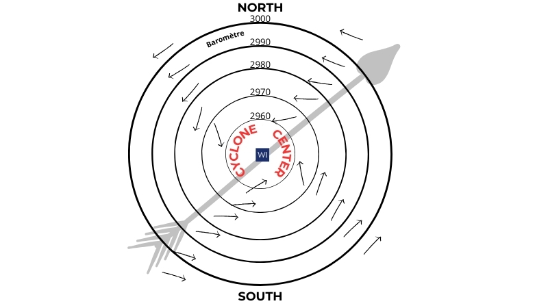
Identifying the eye of the cyclone:

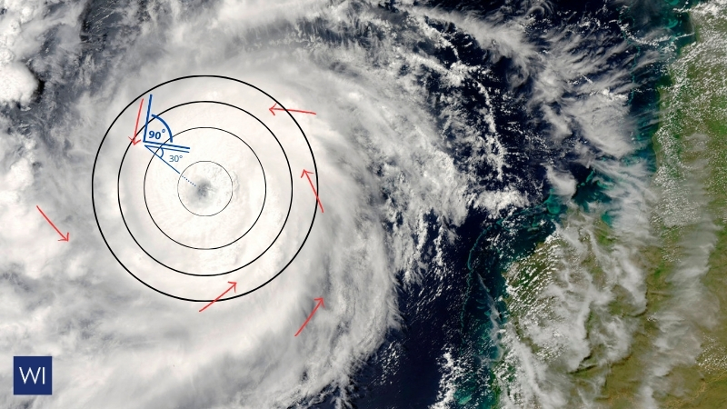
In the Northern Hemisphere, winds rotate around the center in an anti-clockwise direction.
To locate the center of a cyclone in the Northern Hemisphere, follow these steps:
- Stand facing the wind;
- Stretch your right arm out at a 90° angle;
- Then shift it 30° backward.
In the Southern Hemisphere, the wind rotates clockwise around the center.
To find the cyclone’s eye, follow these steps:
- Stand facing the wind;
- Extend your left arm at a 90° angle;
- Then move it 30° backward.
This technique will show you where the cyclone’s eye is located in the Southern Hemisphere.
Learn how to predict cyclones using satellite imagery and weather patterns, and discover the regions most at risk worldwide.
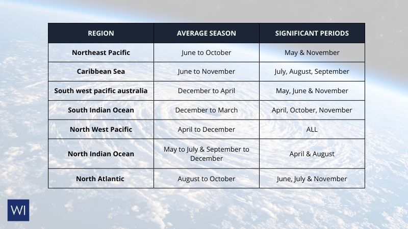
Global Cyclone Risk Zones: An Indicative Table of High-Risk Areas

We do not recommend traveling during cyclone season. In the event of a cyclone, it is essential to stay informed about local weather updates. Please do not hesitate to discuss you. r travel plans with your broker or travel agent for guidance and support. Your safety is our top priority.


